UN-Habitat has worked for decades to bring spatial and long-term planning into post-crisis scenarios. ‘Urban Planning Responses in Post-Crisis Contexts’ highlights strategies and lessons from UN-Habitat’s Urban Planning and Design Lab during the period of UN-Habitat’s 2014- 2019 Strategic Plan. It endeavours to guide practitioners and to increase understanding between the humanitarian and urban planning communities, and discusses the role that urban planning plays in developing holistic post-crisis responses.
The publication outlines the ten different strategies that the Lab has developed to provide effective planning support and tools: (1) putting special emphasis on the planning process; (2) using urban planning as a coordinating tool among actors; (3) quickly structuring an orderly settlement of land for effective service delivery and management; (4) setting the area on a trajectory of long-term sustainability; (5) using a principles-based approach; (6) including and consulting to foster social cohesion and ownership; (7) planning within the larger geography; (8) connecting and aligning with the local government perspective and role; (9) identifying and guiding investments strategically; and (10) creating the plan as a management tool for actors and local governments. It further explores the three typologies of support that the Lab has found to be the most useful in post-crisis contexts: (A) supporting settlement profiling; (B) supporting participatory decision-making; and (C) supporting institutional capacity building.
While each post-crisis response must be carefully tailored to the specific context, and sweeping recommendations cannot be applied across the board, these strategies and support areas are explored in this publication to provide guidance and support to practitioners. The appendices include four detailed case studies that illustrate the applicability of these points in various contexts: Appendix A: Canaan, Haiti; Appendix B: Mogadishu, Bossaso, and Gabiley, Somalia; Appendix C: Kalobeyei, Kenya; and Appendix D: Cox’s Bazar, Bangladesh. Appendix E provides further background on the relevant global frameworks and evolving perspectives related to the humanitarian-development nexus and the UN perspective, and Appendix F provides background information on urban planning at UN-Habitat and its Urban Planning and Design Lab.
The Hamra Neighbourhood Profile undertaken by UN-Habitat and RELIEF Centre builds on a series of neighbourhood profiles of 28 disadvantaged areas in Lebanon, which UN-Habitat and UNICEF have produced in the last few years. Generated within an area-based framework, neighbourhood profiles are reports containing original spatialized multisectoral, multicohort data and analysis. They can provide critical evidence for coordination and programming by local authorities, community organizations, sector specialists, and multisector practitioners.
Old Saida is a predominantly residential neighbourhood located on the Mediterranean shore in the western part of Saida City (Sidon). It falls within the jurisdiction of Saida Municipality, in Lebanon’s South Governorate. The neighbourhood as defined participatively in the field spans 0.18 km2.
This report maps—and suggests the relative criticality across space of—interlinked social, economic and builtenvironment challenges in Old Saida in the context of a poor, conflict-affected neighbourhood. It offers a new area-based knowledge springboard that can be used for coordination and programming. This may be both for alleviating immediate needs and, taking into account the neighbourhood’s embeddedness in the wider city, for longer-term sustainable urban development planning. UN-Habitat and UNICEF recognize that the profile’s value lies only in its uptake and use for these purposes by the municipality and other relevant partners, and look forward to facilitating productive discussions to this end.
Structure Plans for EDE and Environs: State of Osun Structure Plans Project
The Structure plan project was initiated by the Governor of the State of Osun, Ogbeni Rauf Aregbesola who signed a technical cooperation agreement with the United Nations Human Settlements Programme (UN-HABITAT) for the preparation of Structure Plans for nine major cities in the State. The cities are Osogbo, Ede, Ilesa, Iwo, Ikirun, Ila-Orangun, Ile-Ife, Ikire and Ejigbo. This will build on a related initiative – the Osun Urban Renewal Project - designed to regenerate the core areas of these cities. The Structure Plan will incorporate elements of the regeneration strategy and a combination of the two will form the development plan for each city. The overall objective of this project is to support the preparation of Structure Plan for these cities with an overall framework for guiding their development and growth in the next 20 years.
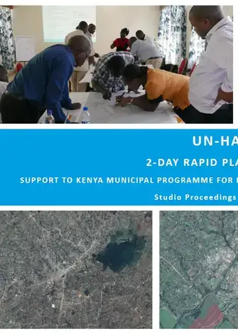
UN-Habitat 2-day Rapid Planning Studio, support to Kenya Municipal Programme for Kakamega, Kericho and Uasin Gishu Counties
Habitat has been providing various training to support governments towards achieving sustainable urban development. In 2012, UN-Habitat developed a new training methodology called Rapid Planning Studio (RPS) to help cities and local governments develop practical, feasible approaches to implementing urban planning interventions. This methodology has successfully been applied to support UN-Habitat’s capacity development activities in Kenya, Rwanda, Mozambique, and the Philippines.
The 2-day training for Kenya Municipal Programme (KMP) Cluster V counties was conducted based on this RPS methodology, to provide decision makers and planners in the counties with enhanced capacity to actively engage with their respective process of formulating an Integrated Strategic Urban Development Plan (ISUDP).
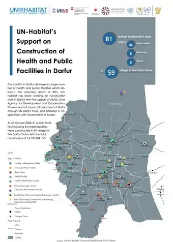
UN-Habitat’s Support on Construction of Health and Public Facilities in Darfur
Responding the urgent need, UN-Habitat constructed/rehabilitated health and public facilities including hospitals, health units, schools, rural courts, education offices, police stations, prosecutor offices, community buildings, markets and so on. As of January 2020, 81 public facilities have been constructed in 59 villages in five Darfur States with the total contribution of 14,159,284 USD.
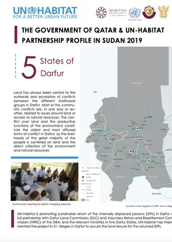
The Government of Qatar & UN-Habitat Partnership Profile in Sudan 2019
Securing land tenure is the fundamental right of every individual. It is particularly important for the vulnerable groups including female-headed households. The project “Strengthening Land Management for Peaceful Co-Existence in Darfur” (2015-2018) was designed to improve current land title system in Darfur and to contributes in the development of evidence-based land policies, laws and regulations.
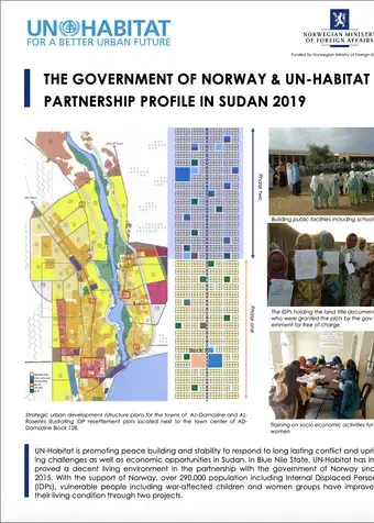
The Government of Norway & UN-Habitat Partnership Profile in Sudan 2019
The 4-page brochure showcases the two projects in Blue Nile funded by the Government of Norway: “Promote Peace building and Stability in the Blue Nile” (2016-2019), and “Strategic Urban Development/Structure Plans for the Towns of Ad-Damazine and Al-Roseiris” (2015-2016) with the project outlines, achievements, and voices from the beneficiaries.
The Future Saudi Cities Programme is a joint programme developed by the Ministry of Municipal and Rural Affairs in Saudi Arabia and UN-Habitat, implemented in close cooperation with the municipalities of 17 major Saudi cities, the cities have been selected based on their different population sizes, geographic distribution, and a range of criteria based on capacities and economic potential to create a more balanced regional development among the cities of Saudi Arabia. The chosen cities include Riyadh, Makkah, Jeddah, Taif, Madinah, Tabuk, Dammam, Qatif, Al-Ahsa, Abha, Najran, Jazan, Hael, Arar, AlBaha, Buraidah, and Skaka. one of FSCP outcomes is the city profiles.
The city-profile performs as a thinking tool that constitutes together an assessment tool and guidance for the current and future planning of the city, whilst defining a clear strategy for sustainable development. This tool is based on the UN-Habitat’s three-pronged approach considers spatial planning in relation to legal and institutional frameworks, in addition to financial mechanisms. In this way, success criteria for the sustainable implementation of a spatial plan should include flexible but enforceable rules and regulations, in addition to a financing strategy and projections.
The City Profile Methodology, that is applied to Tabuk, is contenting the following steps:
1- Evidence based input approach.
2- The City reviews.
3- The City Prosperity Index assessment report.
4- The GIS spatial analysis.