Despite the inevitable nature of pandemics such as COVID-19, the health and socio-economic impacts have sent shockwaves through cities and towns globally revealing structural weaknesses in our urban systems. This particular crisis is unfortunately also aggregating in humanitarian contexts and places such as refugee settlements where systems are particularly fragile; placing huge pressure upon communities who are among those least well-equipped to cope. Displaced communities living in camp/camp-like settings often suffer from pre-existing marginalization, inequalities and vulnerabilities now compounded by this emergency. They now face increased risk due to intense overcrowding, limited (or no) capacity for physical distancing, sub-standard shelter, as well as poor nutritional and health status which can be exacerbated by assistance modalities involving large crowds.
UN-Habitat’s work in Kalobeyei and Kakuma in Turkana County, Kenya focuses upon supporting refugees and their hosting communities, aiming to improve access to basic service infrastructure, shelter and socio-economic opportunities through spatial profiling and planning interventions. The support to these communities continues to be based upon the premise that development trajectories in the long-term will be affected by the support received in humanitarian contexts and operational decisions made “now”. As COVID-19 presents a global humanitarian crisis, the urgent need for effective humanitarian and development collaboration and coherence is more relevant than ever. Furthermore as scarce resources become increasingly strained, and the nature of this challenge places pressure on national and local governments globally, it is imperative that COVID crisis response interventions serve a dual purpose - both to support partners and communities to cope with this response and to fundamentally build-in improved systemic resilience to shocks.
The ongoing work in Turkana takes an urban systemic lens and leverages grassroots community networks through which to target humanitarian preparedness planning, inform a) recovery planning; and b) improved infrastructure investments to enable robust pathways to self-reliance and sustainable development for the wider community. Linking humanitarian and development initiatives, the team is re-contextualising spatial profiling methodologies developed in partnership with UNHCR and piloted in Uganda and Ethiopia to quickly realise multiple dividends. In the context of COVID, a rapidly developed reliable baseline of information to inform targeted and coordinated interventions to combat potential spread of pandemic and guides directed support to vulnerable groups is proving increasingly essential. The spatial profiling methodology utilises rapidly developed analysis leveraging existing information, platforms and partners to reduce transaction costs and improve coordination to inform both the humanitarian response as well as to support in developing evidenced based spatial strategies linked to longer term legacy scenarios.
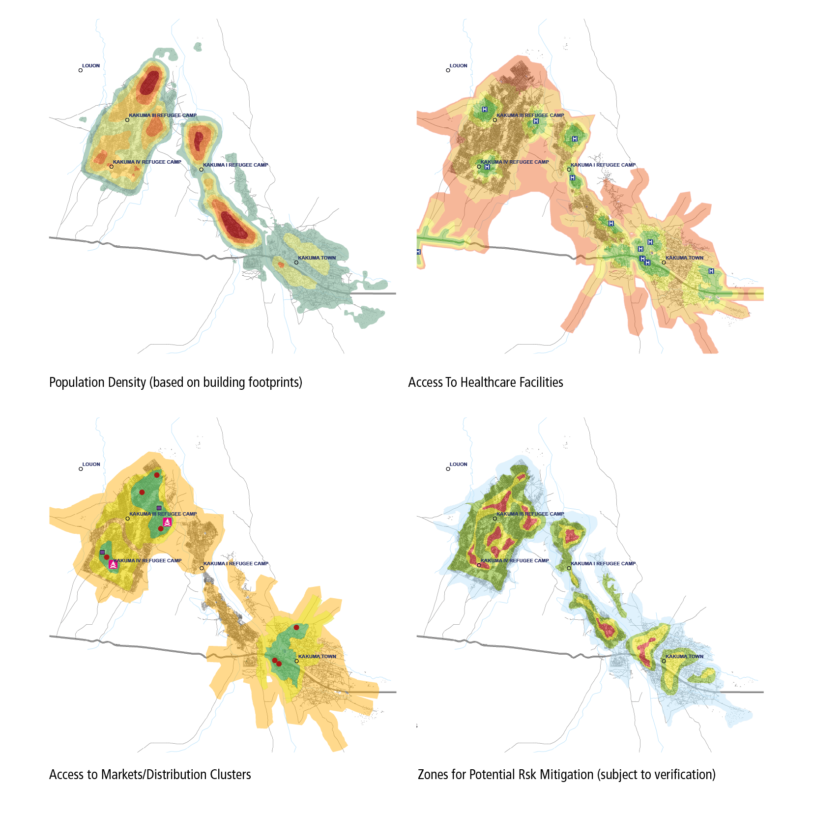
During this emergency phase, the methodology identifies risk hotspots through a process of spatial data analysis. This includes mapping an overlay of access routes, areas with high population density and clusters of facilities that draw crowds (e.g. distribution centres, water points, marketplaces). In these areas, physical distancing (alongside other mitigation measures) can be put in place to limit the potential risk of spreading infection. Running in tandem is analysis to identify the pockets of vulnerable populations who are located far from services or face access barriers and may need support interventions to ensure provision of service in the case of a potential infection. The findings help in identifying immediate support needs and revealing infrastructure weak spots and systemic gaps which can inform medium/long term interventions. Through working with both host and refugee populations and by bringing a holistic lens to the response, UN-Habitat is uniquely placed to tap into both large-scale data to run spatial analyses as well as community-based field teams to ground strategic perspectives with grass roots realities.
This approach also allows for the incorporation of wider development considerations to guide incremental improvements and particularly reduce the long-term risks faced by displaced populations. The strategic infrastructure analyses can focus on bolstering settlement resilience by identifying potential opportunities to plug gaps in infrastructure and enable access to wider socio-economic opportunities, improved service provision and employment.
UN-Habitat’s work in Turkana County is expressly aligned with both the UN’s Global Humanitarian Response Plan and the Framework for the Immediate Socio-Economic Response to COVID-19, which supports local capacities in working towards the attainment of the SDGs. The profiling information helps to outline spatial demand, streamline the management of crisis situations and form consensus around prompt action. This enables both a response to the crisis now, whilst maintaining a focus upon providing safe and dignified living conditions for displaced populations whilst protecting hosting communities and building a path towards improved socio-economic opportunities for all.
"Spatial Assessment Tool project funded by European Union Trust Fund"